Conference on Computer Vision and Pattern Recognition - Workshop (CVPR-W), 2026
We developed a unified multimodal GeoAI framework that learns shared representations from satellite imagery, audio, and text to predict and map realistic soundscapes anywhere on Earth.
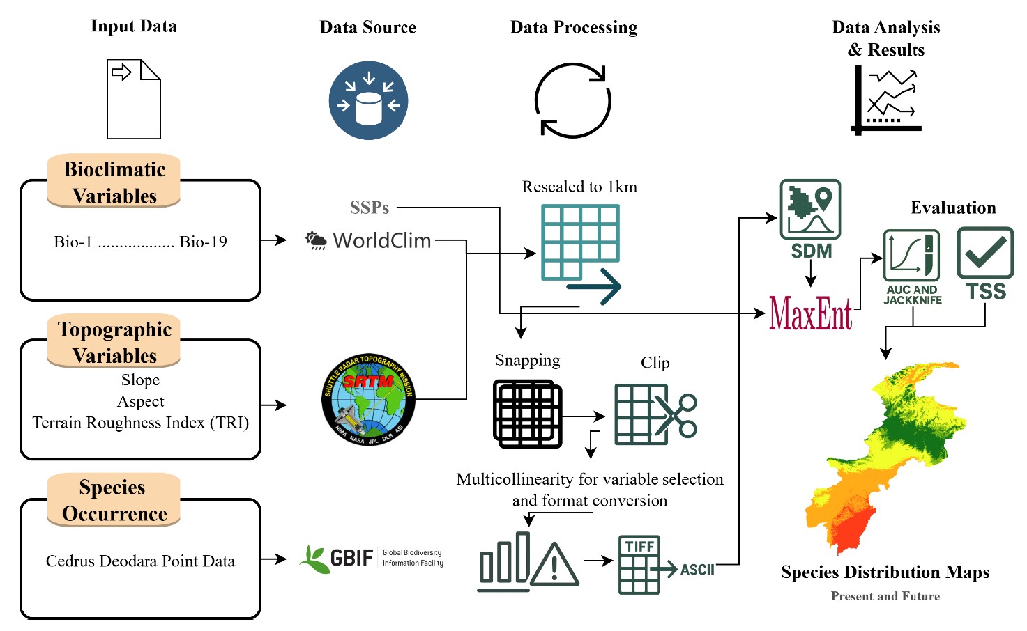
We predict current and future habitats of Cedrus deodara using MaxEnt, showing precipitation-driven suitability and significant future habitat contraction under climate change.
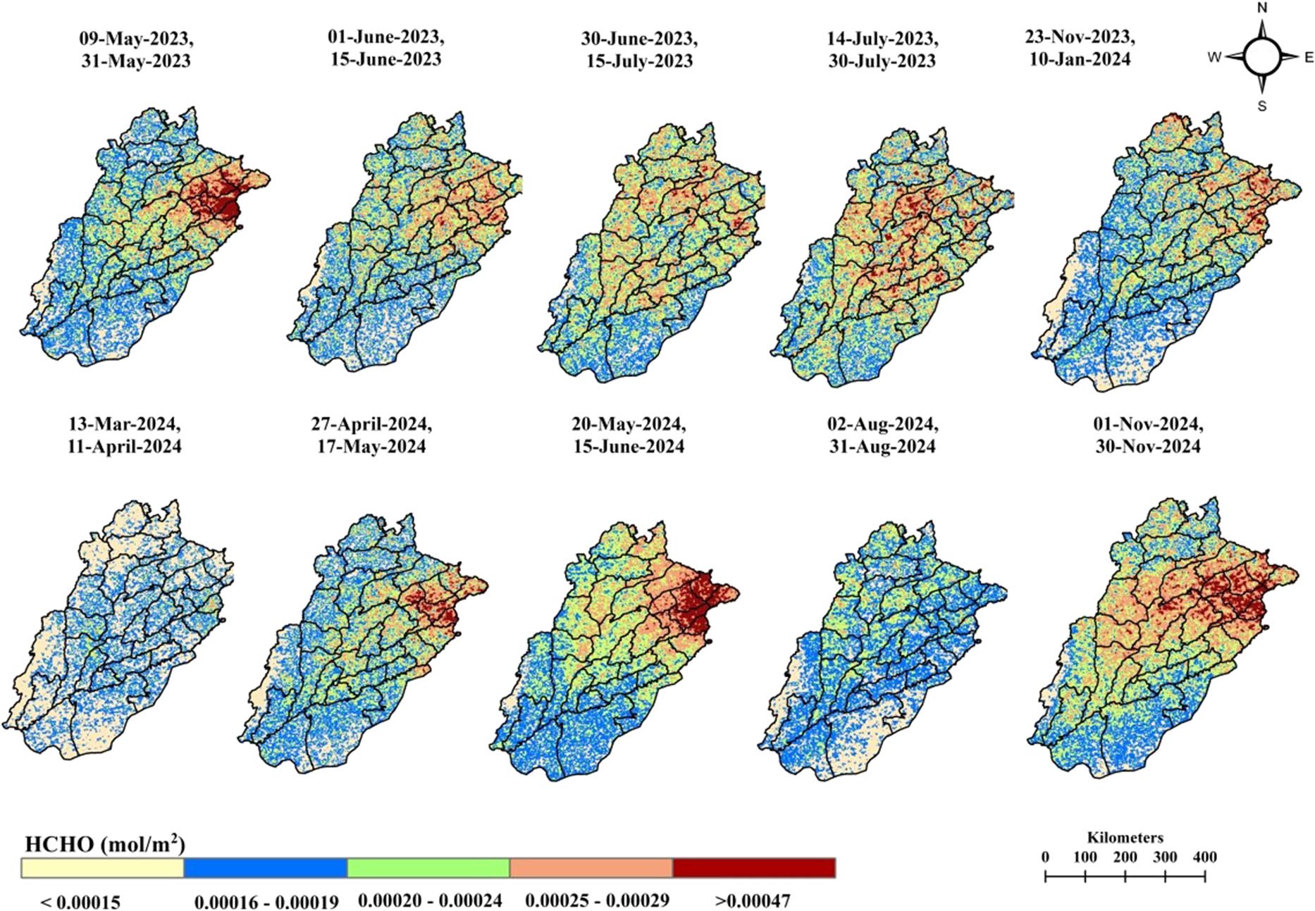
We use Sentinel-5P data to assess how COVID-19 lockdowns affected key air pollutants across Punjab, revealing a strong drop in NO₂ and mixed trends in CO, SO₂, and HCHO. The findings support more targeted air-quality actions for protecting public health.
Aayush Dhakal, Srikumar Sastry, Subash Khanal, Adeel Ahmad, Eric Xing and Nathan Jacobs
Conference on Computer Vision and Pattern Recognition (CVPR), 2025
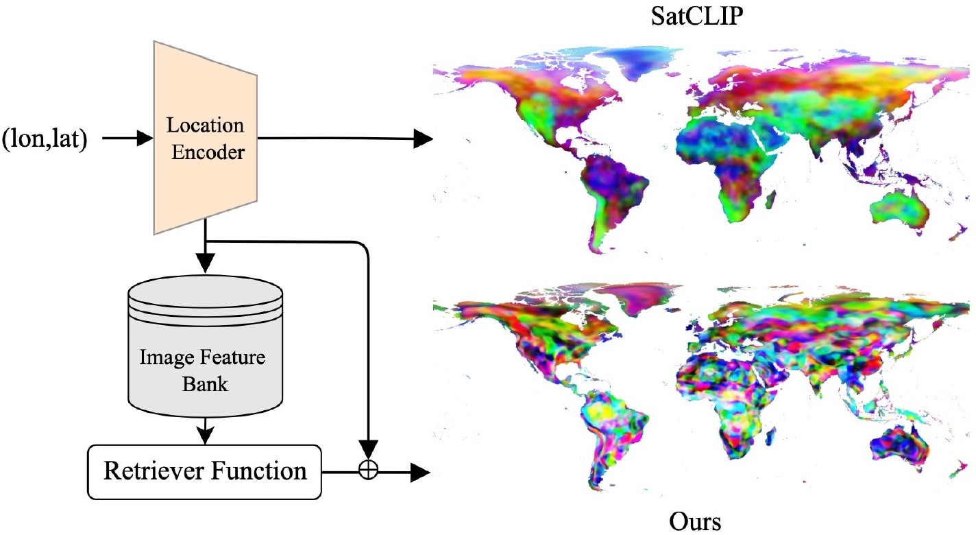
We propose a novel retrieval-augmented strategy for multi-resolution geo-embeddings, called RANGE. Our method is based on the intuition that the visual features of a location can be estimated by aggregating visual features from multiple similar-looking locations.
Hannah Kerner, Snehal Chaudhari, Aninda Ghosh, Caleb Robinson, Adeel Ahmad, Eddie Choi, Nathan Jacobs, Chris Holmes, Matthias Mohr, Rahul Dodhia, Juan M Lavista Ferres and Jennifer Marcus
Proceedings of the AAAI Conference on Artificial Intelligence, 2025
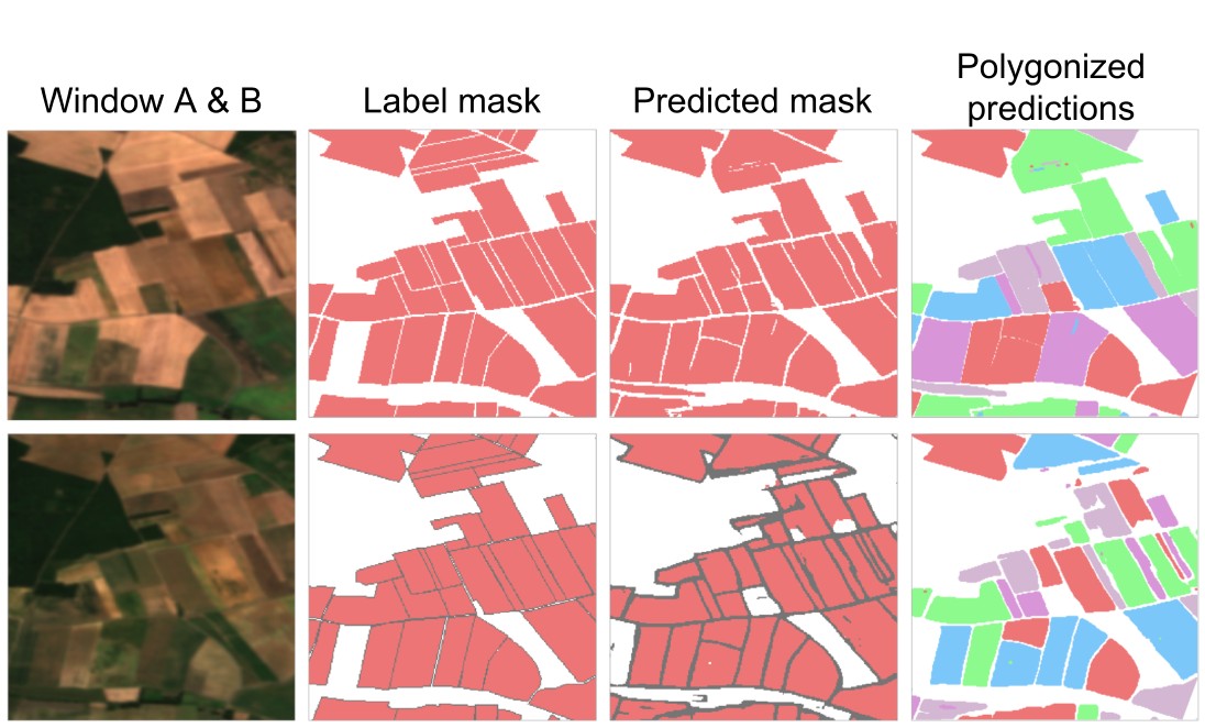
We developed Fields of The World (FTW), the largest global dataset for crop field boundary segmentation, to advance more accurate and generalizable ML models for agricultural monitoring.
Ana Luiza Favarão Leão, Bernard Banda, Eric Xing, Sanketh Gudapati, Adeel Ahmad, Jonathan Lin, Srikumar Sastry, Nathan Jacobs and Rodrigo Siqueira Reis
Journal of Public Health, 2025
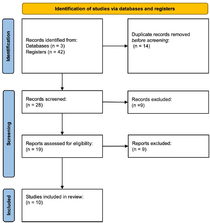
In this review we found that while AI holds great promise for improving urban health research, there's a critical need to integrate spatial equity into these studies. Only 10% of the studies we reviewed explicitly considered spatial inequities, highlighting an important gap in the field.
Srikumar Sastry, Subash Khanal, Aayush Dhakal, Adeel Ahmad and Nathan Jacobs
IEEE/CVF Winter Conference on Applications of Computer Vision (WACV), 2025
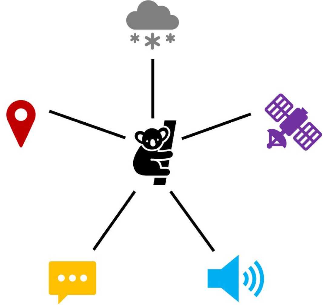
TaxaBind is a suite of multimodal models useful for downstream ecological tasks covering six modalities: ground-level image, geographic location, satellite image, text, audio, and environmental features.
Adeel Ahmad, Sajid Rashid Ahmad, Hammad Gilani and Jakub Nowosad
Environmental Monitoring and Assessment, 2025
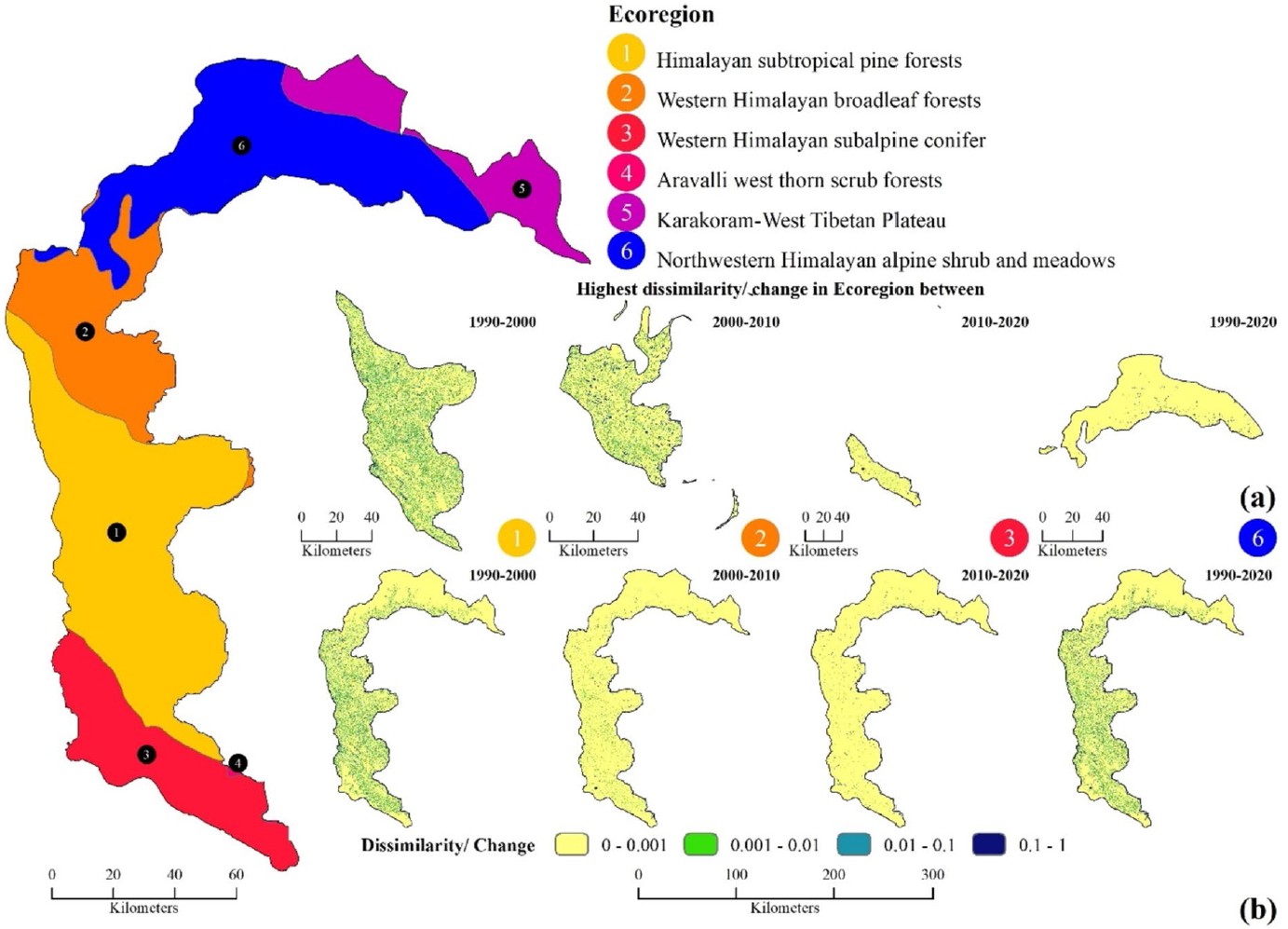
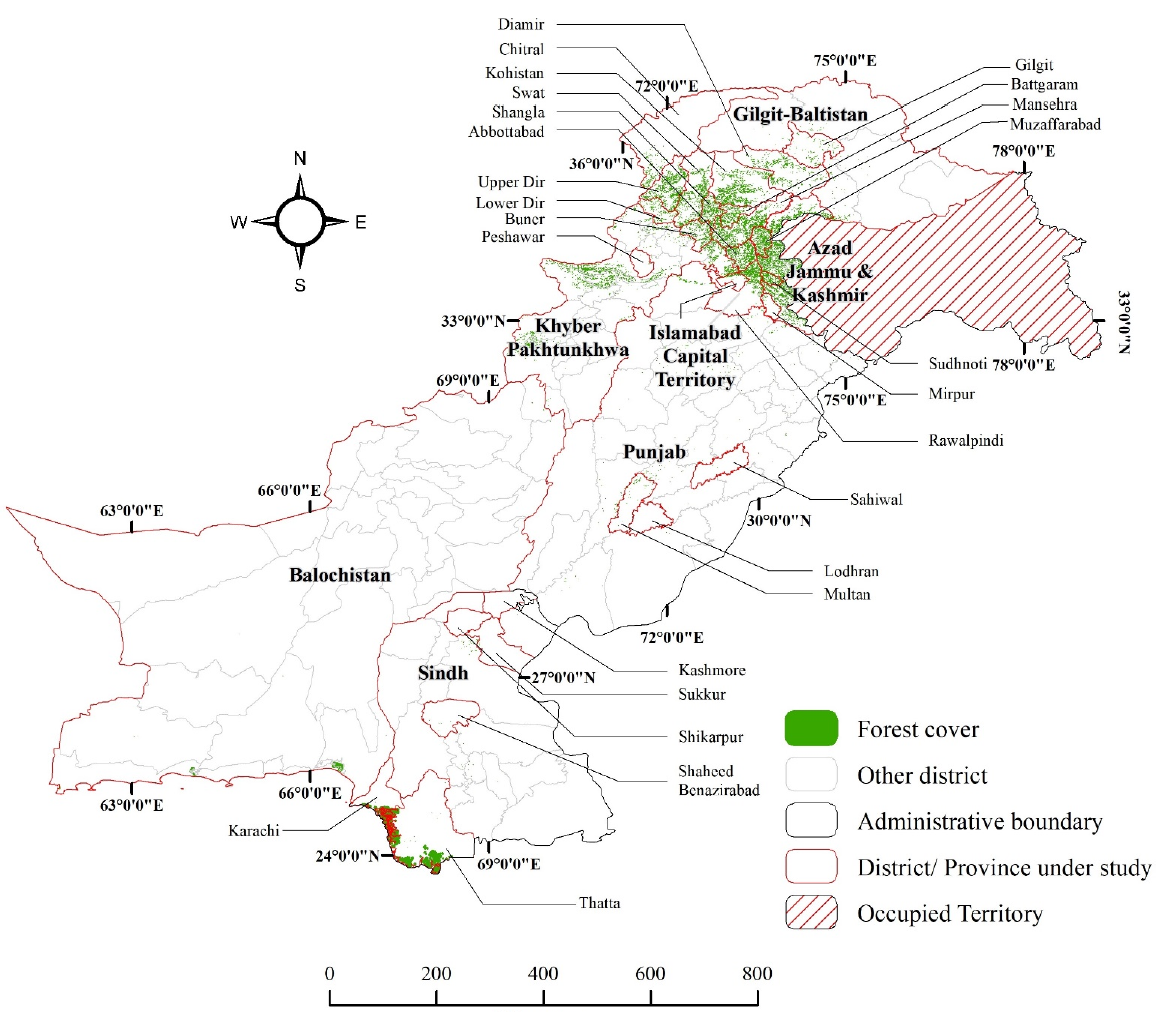
We analyzed three decades (1990–2020) of Landsat imagery to assess forest cover change and fragmentation in Azad Jammu and Kashmir, revealing gradual decline, increased patchiness, and critical hotspots to guide conservation and UN-REDD⁺ strategies.
Sadaf Safdar, Isma Younes, Adeel Ahmad and Srikumar Sastry
Kuwait Journal of Science, 2025
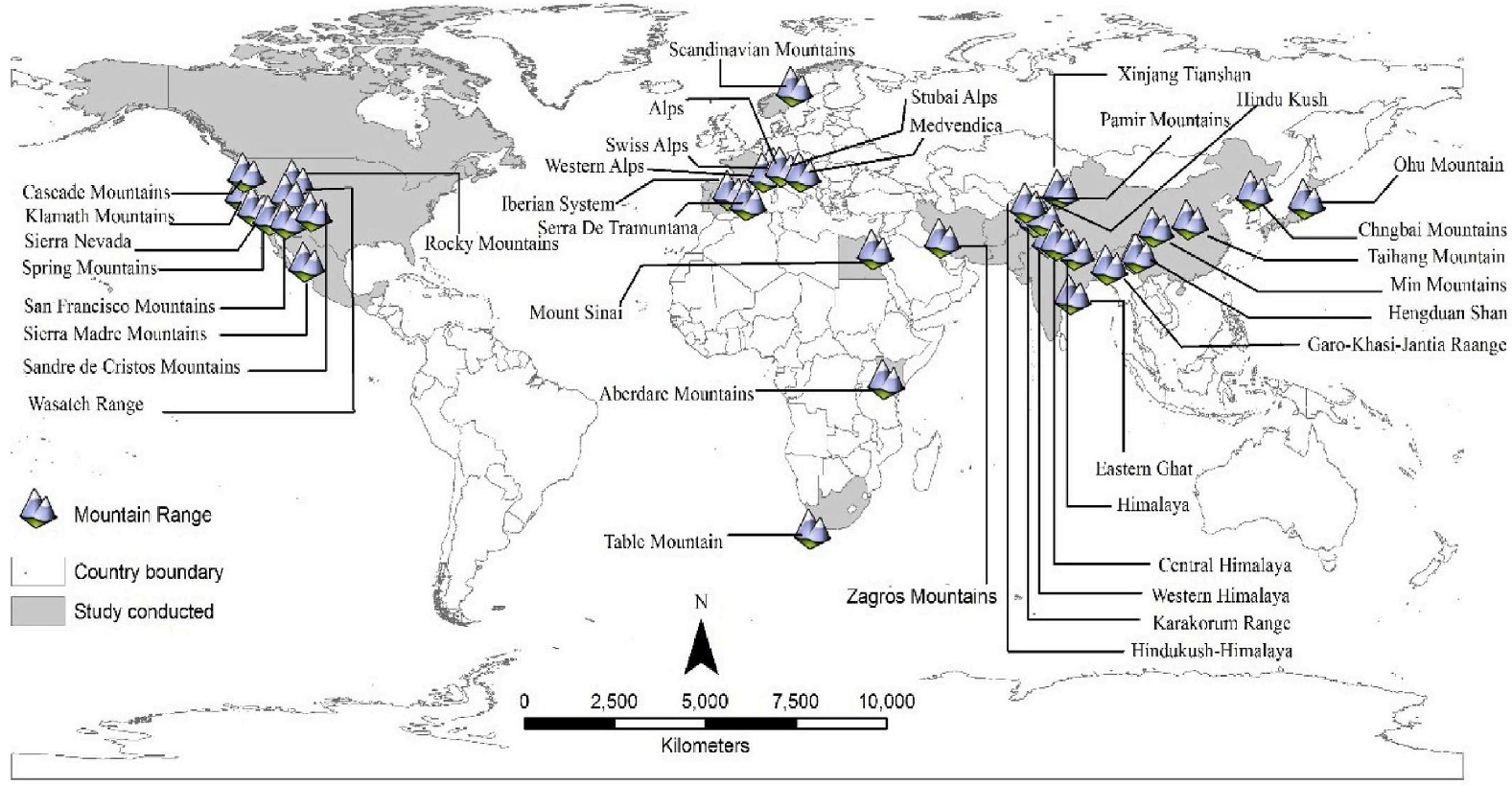
We conducted the first global review of Species Distribution Modelling in mountainous environments (1997–2022), highlighting the growing role of remote sensing and machine learning in supporting forest management under climate change.
Subash Khanal, Eric Xing, Srikumar Sastry, Aayush Dhakal, Zhexiao Xiong, Adeel Ahmad and Nathan Jacobs
Association for Computing Machinery (ACM) International Conference on Multimedia, 2024
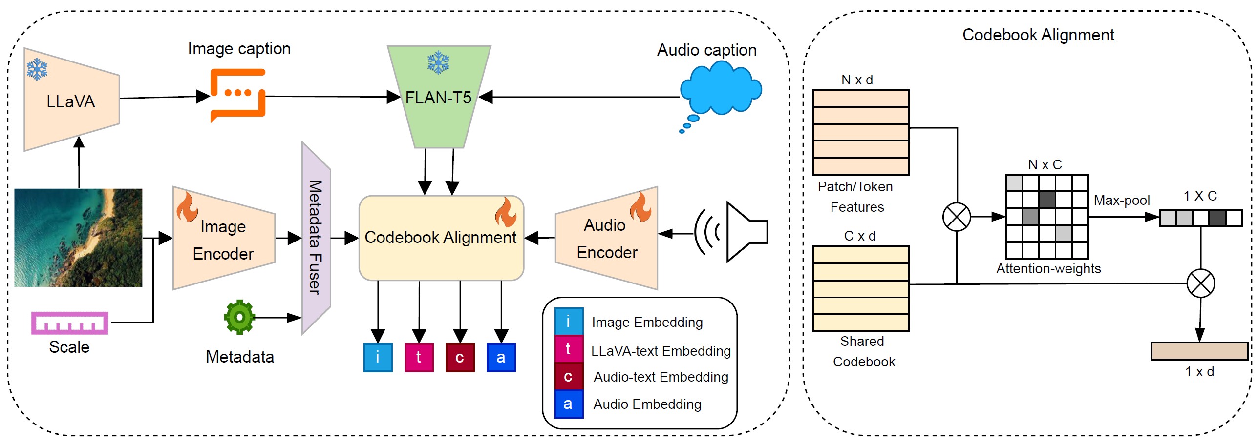
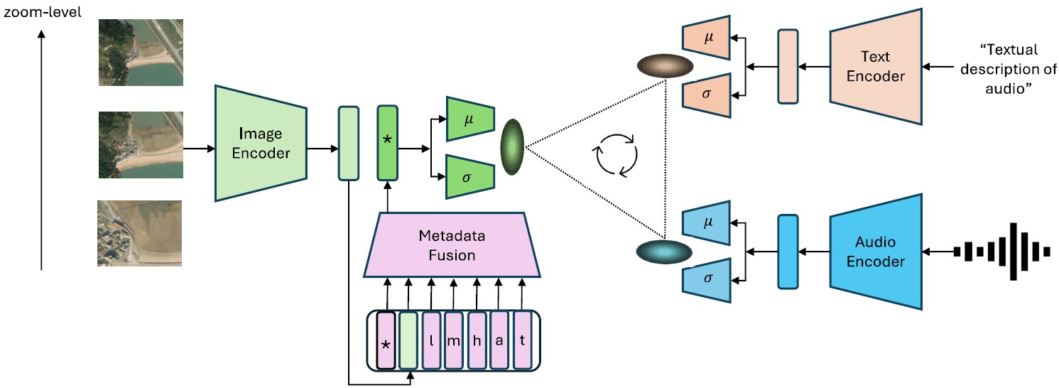
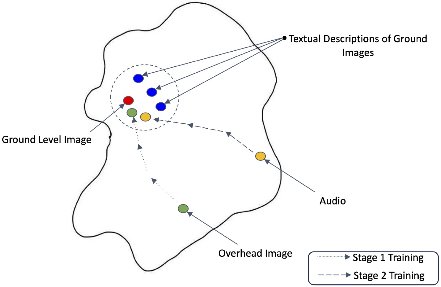
We develop a probabilistic, multi-scale, and metadata-aware embedding space that connects audio, text, and overhead imagery. This enables the creation of dynamic, multi-scale soundscape maps for any geographic region, along with uncertainty estimates for the mapping.
Adeel Ahmad, Aayush Dhakal, Srikumar Sastry, Subash Khanal, Eric Xing and Nathan Jacobs
American Geophysical Union (AGU), 2024
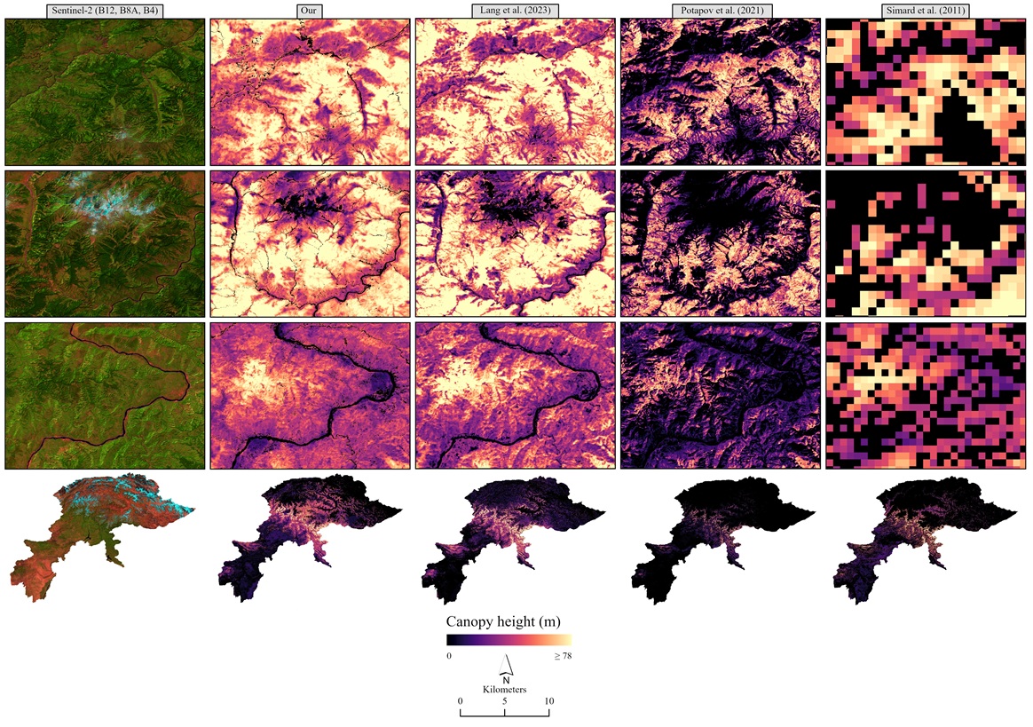
We extended deep learning approaches combining GEDI LiDAR and satellite imagery to predict forest vertical structural diversity across complex landscapes, advancing understanding of carbon sequestration, biodiversity, and ecosystem processes.
Srikumar Sastry, Adeel Ahmad, Aayush Dhakal, Subash Khanal, Eric Xing and Nathan Jacobs
American Geophysical Union (AGU), 2024
We present a generative model that synthesizes realistic, multi-temporal satellite imagery conditioned on location, text, or layout, enabling simulations of past, present, and future Earth surface scenarios.
Hannah Rae Kerner, Snehal Chaudhari, Aninda Ghosh, Caleb Robinson, Adeel Ahmad, Eddie Choi, Nathan Jacobs, Christopher Holmes, Matthias Mohr and Jennifer Marcus
American Geophysical Union (AGU), 2024
We highlighted the importance of field boundaries as core geospatial datasets, essential for agricultural assessments, climate policies, and MRV of greenhouse gas emissions and sustainable land management.
Munazza Fatima, Adeel Ahmad, Ibtisam Butt, Sana Arshad and Behzad Kiani
Environmental Monitoring and Assessment, 2024
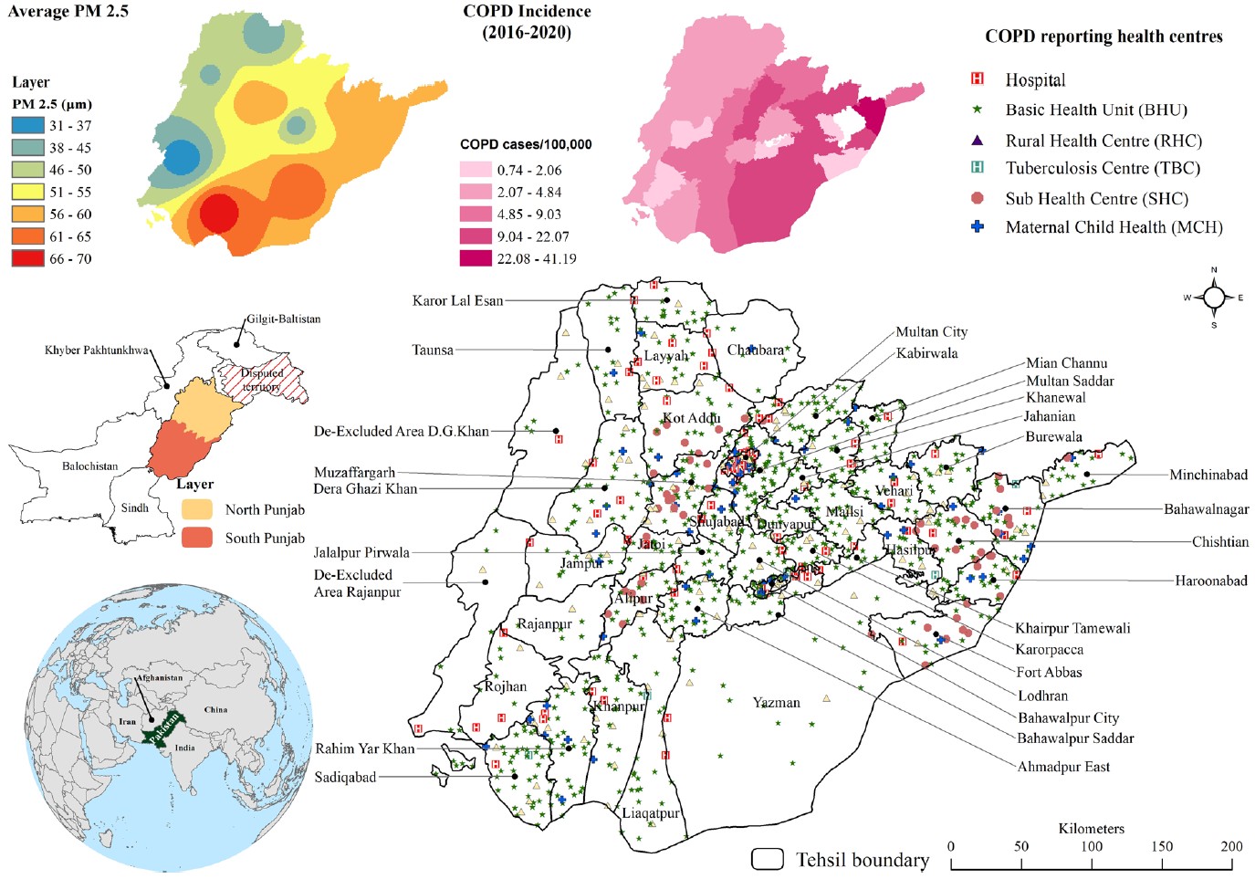
We examined COPD incidence in Pakistan (2019–2020) using spatial scan statistics and machine learning, revealing pollution-linked clusters and highlighting the urgent need for air quality interventions.
Aneeq Ur Rehman, Adeel Ahmad, Yumna Sadef and Sajid Rashid Ahmad
Indonesian Journal of Geography, 2024
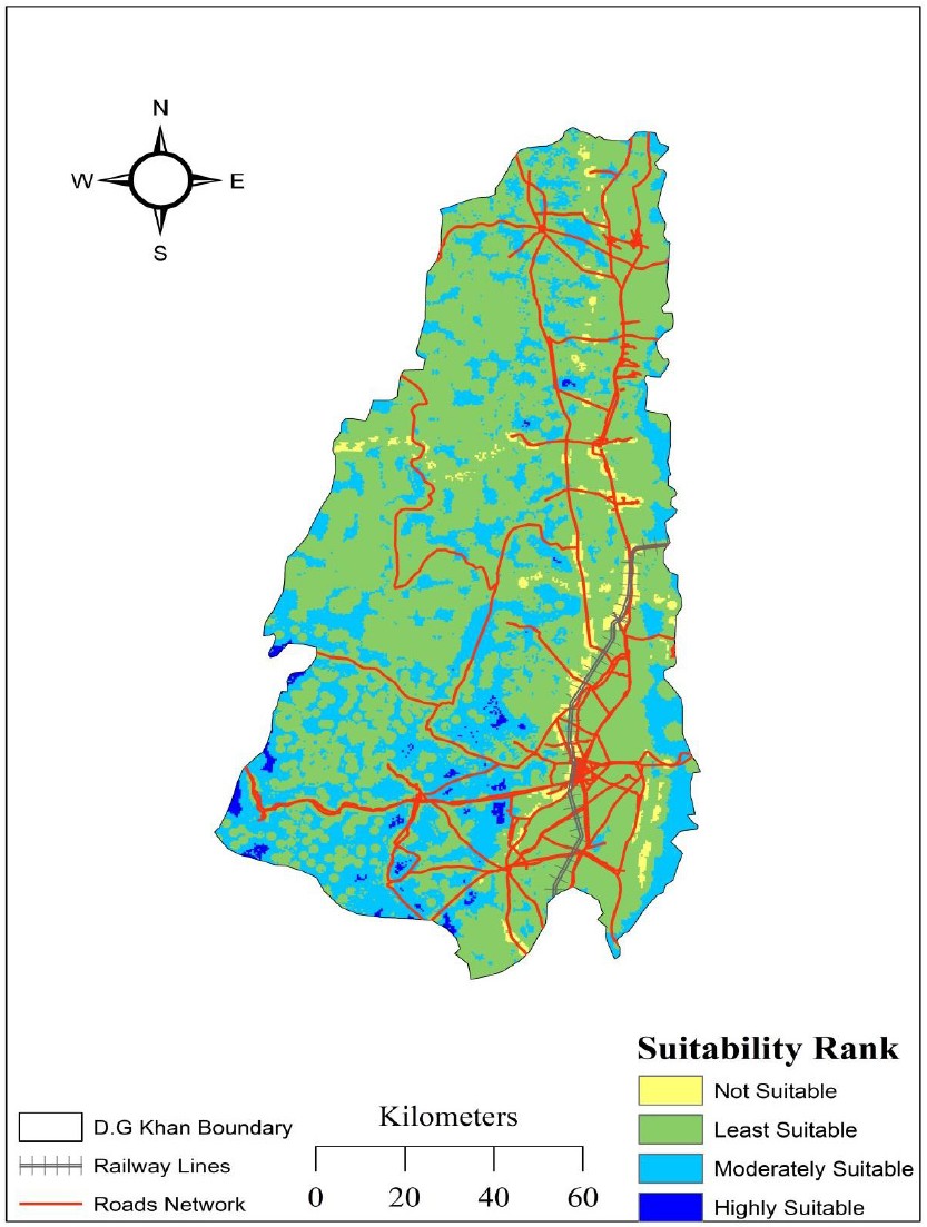
We applied GIS, remote sensing, and AHP to identify suitable solid waste disposal sites in D.G. Khan, providing policymakers with a spatial framework to reduce environmental and health risks.
Aayush Dhakal, Subash Khanal, Srikumar Sastry, Adeel Ahmad and Nathan Jacobs
IEEE International Geoscience and Remote Sensing Symposium (IGARSS), 2024
We developed GeoBind, a deep-learning model that uses satellite imagery to align text, image, and audio into a shared embedding space, enabling versatile multimodal reasoning about geographic locations.
Danish Raza, Mudassar Khushi, Hong Shu, Hasnat Aslam, Muhammad Sajid Saleem, Adeel Ahmad, Sahar Mirza, Urooj Saeed and Sami Ullah Khan
Environmental Earth Sciences, 2024
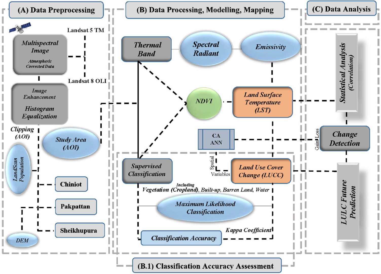
We analyzed multi-year Landsat data to assess urban heat island dynamics in Punjab’s districts, showing how land cover change drives surface temperature variations and forecasting future scenarios with CA modeling.
Conference on Computer Vision and Pattern Recognition - Workshop (CVPR-W), 2024, Best Paper Award
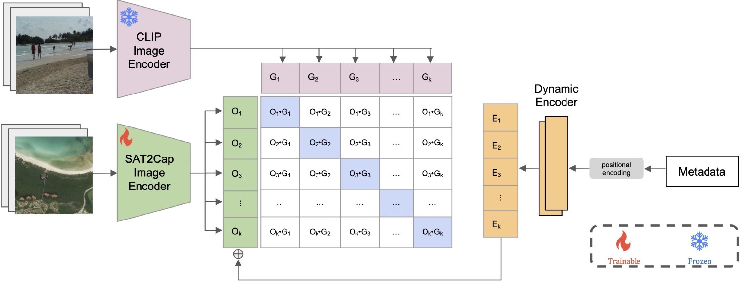
We introduced Sat2Cap, a weakly supervised framework for zero-shot mapping that learns textual concepts from satellite imagery via contrastive alignment, enabling scalable multimodal mapping without text-labeled data.
Mudassar Khushi, Danish Raza, Muhammad Kamran, Majid Nazir, Adeel Ahmad, Sami Ullah Khan and Imtiyaz Younas
Desalination and Water Treatment, 2023
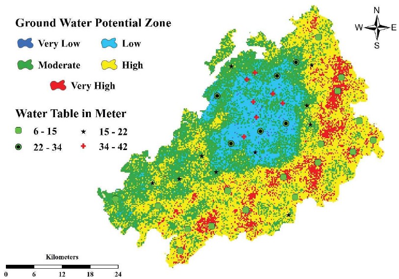
We mapped groundwater potential zones in Lahore using ten geospatial parameters and weighted overlay analysis, providing a validated framework to guide sustainable agricultural water management.
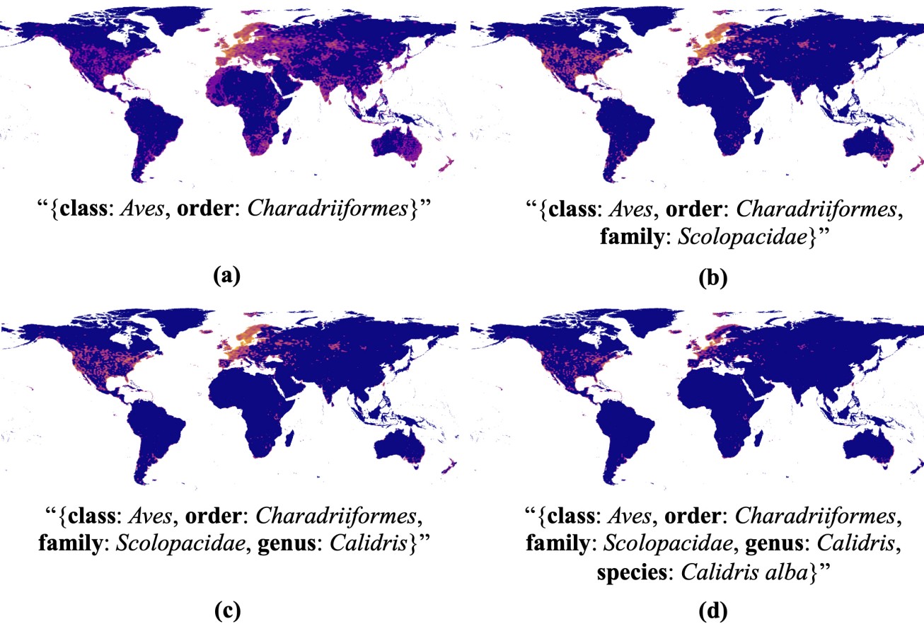
We developed a species distribution model that integrates taxonomic hierarchy via large language models, enabling zero-shot range prediction and introducing a novel proximity-aware evaluation metric that outperforms existing baselines.
Nausheen Mazhar, Kanwal Javid, Muhammad Ameer Nawaz Akram, Amna Afzal, Kiran Hamayon and Adeel Ahmad
Geography, Environment, Sustainability, 2023
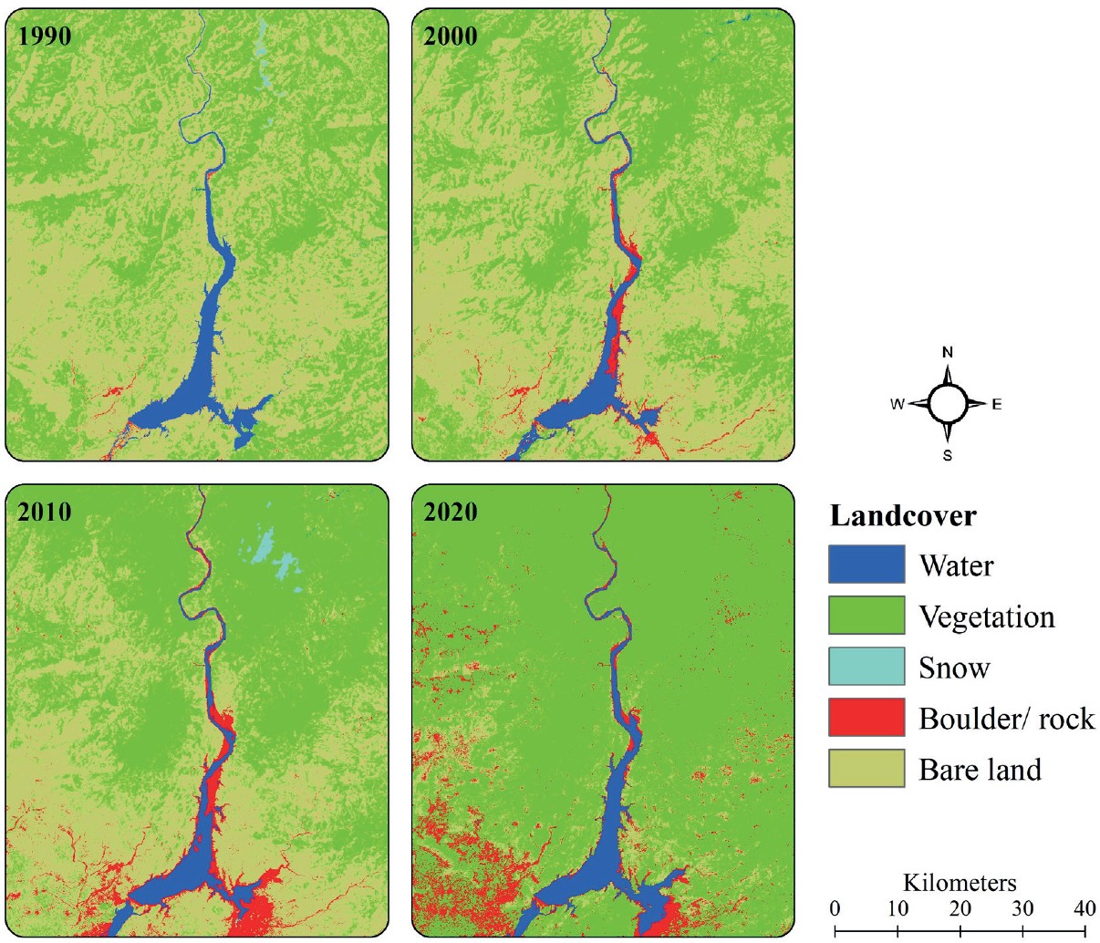
We analyzed multi-year Landsat data to assess water quality dynamics in Tarbela reservoir, finding long-term deterioration but signs of environmental healing in 2020, with policy implications for sediment and turbidity management.
In Concepts and Applications of Remote Sensing in Forestry, 2023
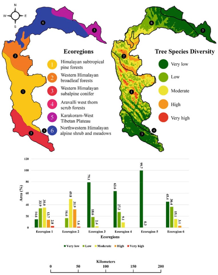
We applied MaxEnt modeling with 26 climatic, biophysical, and topographic variables to predict the potential distribution of four native tree species in AJK, identifying hotspots for conservation and sustainable forest management.
Nouman Afzal, Adeel Ahmad, Safdar Ali Shirazi, Isma Younes and Le Thi Thu Ha
EQA - International Journal of Environmental Quality, 2022
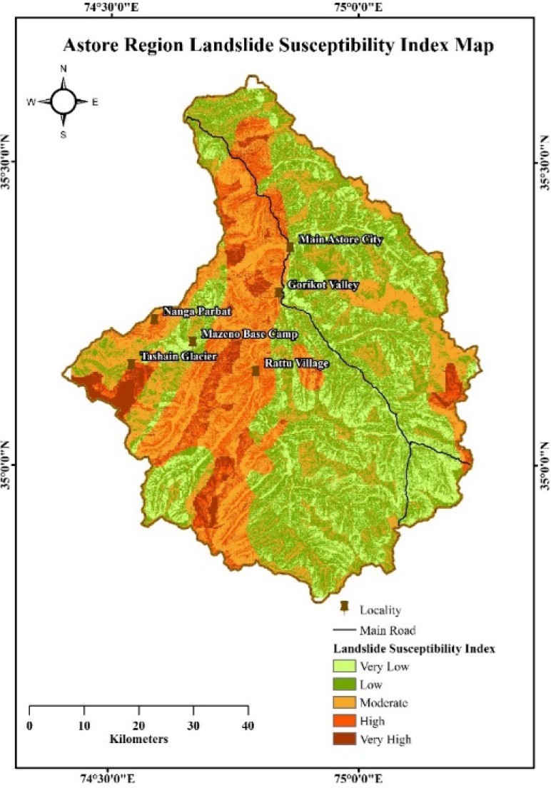
We performed landslide susceptibility analysis in Astore, Pakistan using GIS, remote sensing, and AHP, identifying five risk zones with slope, lithology, and land cover as key triggering factors.
International Journal of Innovations in Science & Technology, 2022
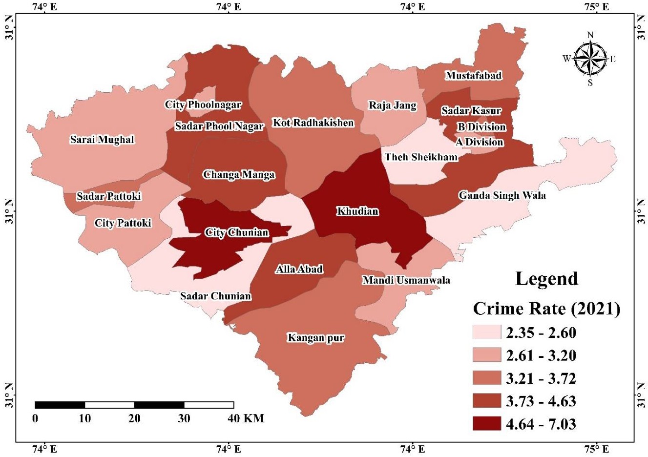
We mapped police-station-level crime data (murder, rape, kidnapping, vehicle theft and dacoity) for District Kasur in 2021 using GIS interpolation, producing crime type, rate and density maps to show how geospatial tools can support policing and law enforcement.
Naveed Ahmed, Genxu Wang, Martijn J Booij, Gokmen Ceribasi, Mohd Sultan Bhat, Ahmet Iyad Ceyhunlu and Adeel Ahmad
Stochastic Environmental Research and Risk Assessment, 2022
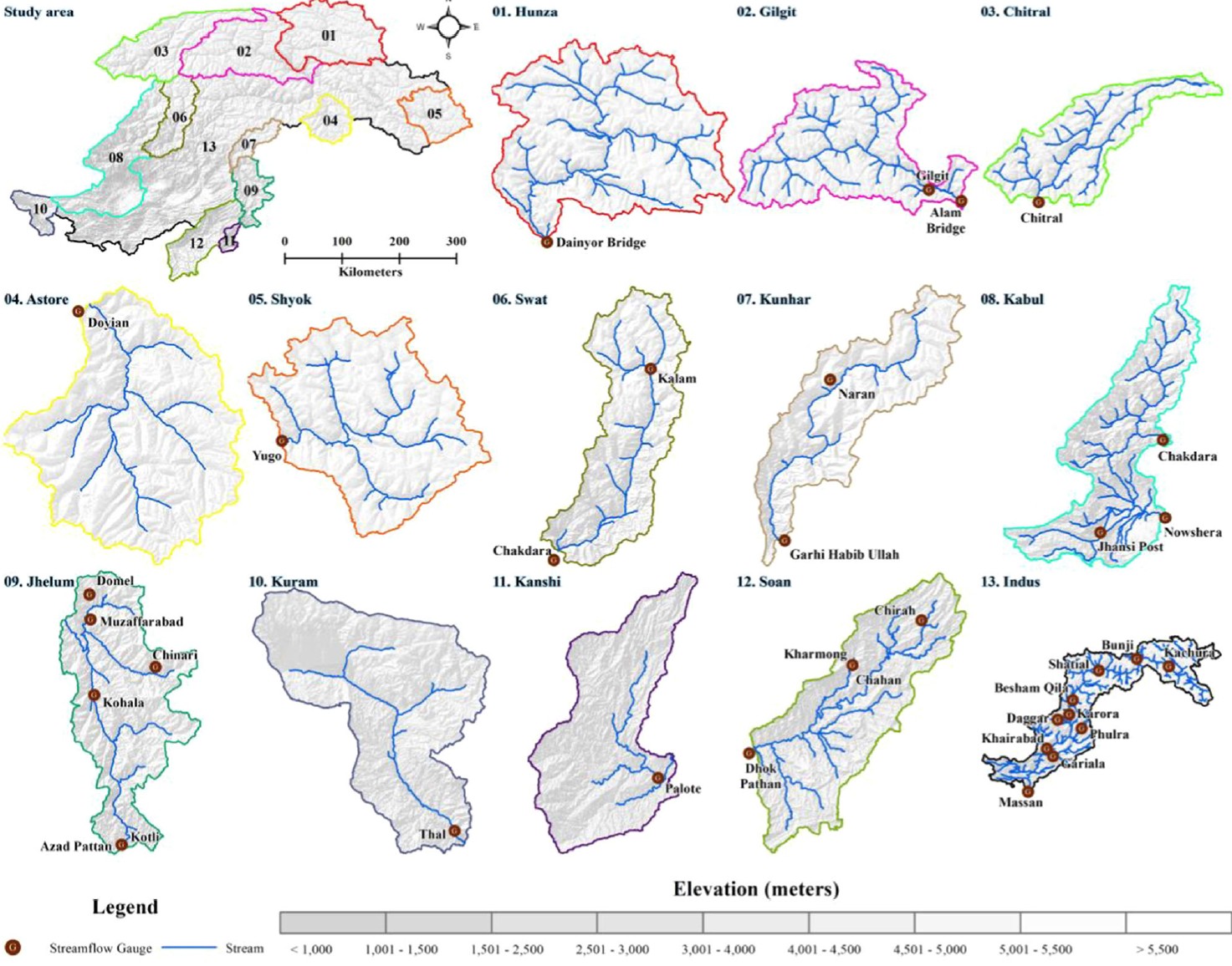
We analyzed monthly streamflow trends across 13 HKH sub-basins in Pakistan using innovative polygon trend analysis, revealing increased flows in glaciated basins and widespread decreases downstream, with implications for floods, hydropower, and water management.
Adeel Ahmad, Hammad Gilani, Safdar Ali Shirazi, Hamid Reza Pourghasemi and Ifrah Shaukat
Express Sunday Magazine, 2022
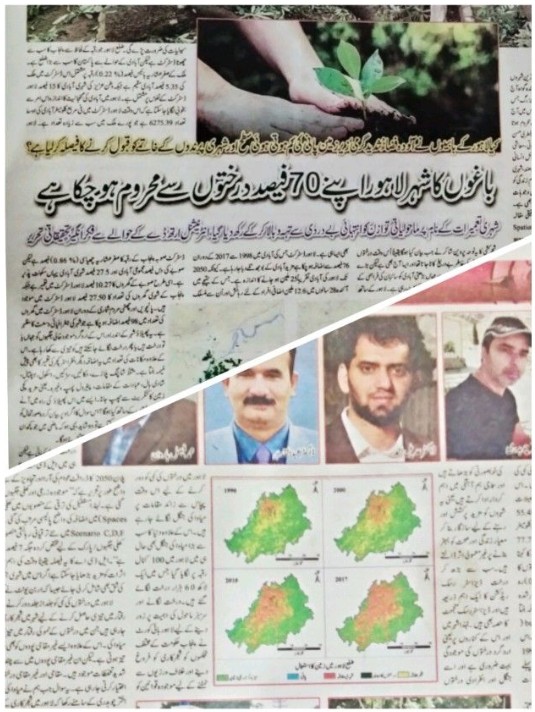
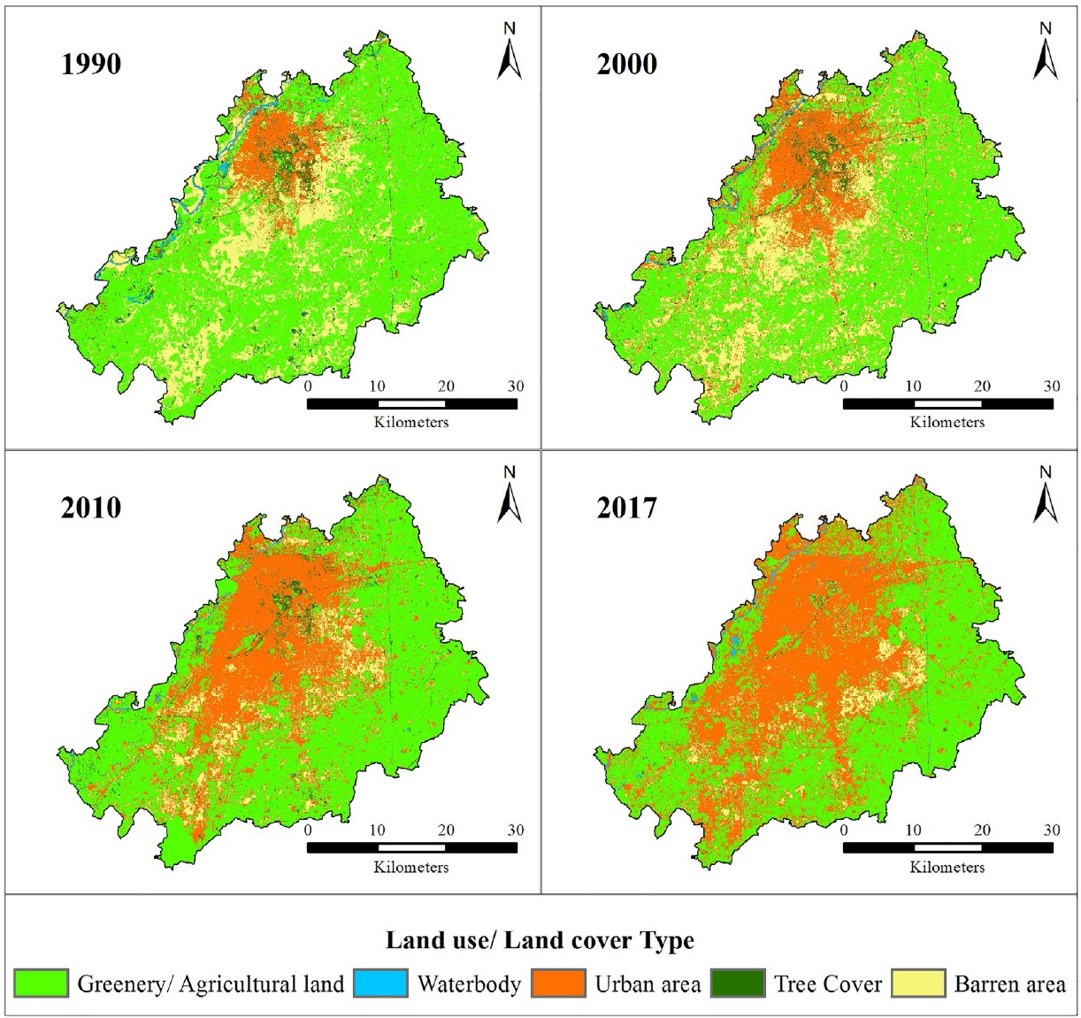
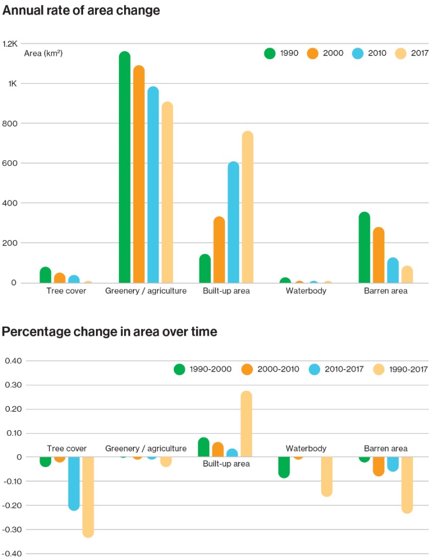
We highlighted the rapid urban sprawl of Lahore, showing significant loss of tree cover (1990–2017) alongside expanding built-up areas, underscoring urgent needs for urban greening and sustainable planning.
Adeel Ahmad, Hammad Gilani, Safdar Ali Shirazi, Hamid Reza Pourghasemi and Ifrah Shaukat
In Computers in Earth and Environmental Sciences, 2022
We analyzed 1990–2017 Landsat data with GEE and CART classification to map urban sprawl, LST, and land cover change in Lahore, revealing rapid urban growth, tree and green space loss, and rising temperatures, with implications for sustainable urban planning.
Hammad Gilani, Adeel Ahmad, Isma Younes and Sawaid Abbas
Land Degradation & Development, 2022
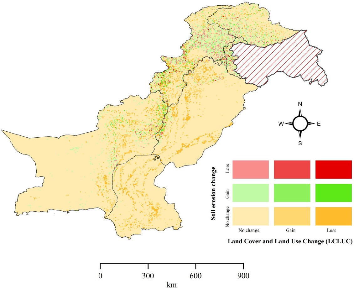
We assessed soil erosion dynamics across Pakistan (2005–2015) using RUSLE and six influencing factors, revealing intensified erosion driven by land use changes, with implications for targeted conservation policies.
Rahat Tufail, Adeel Ahmad, Muhammad Asif Javed and Sajid Rashid Ahmad
Advances in Space Research, 2021
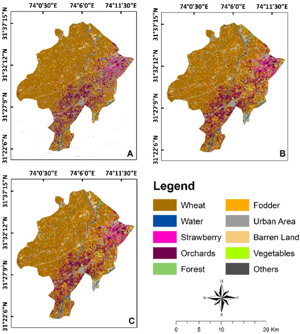
We combined Sentinel-1 SAR and Sentinel-2 optical time-series data with a random forest classifier to achieve 97% accuracy in crop type mapping, demonstrating the power of integrating radar and optical imagery for precision agriculture.
Adeel Ahmad, Sajid Rashid Ahmad, Hammad Gilani, Aqil Tariq, Na Zhao, Rana Waqar Aslam and Faisal Mumtaz
Forests, 2021
We synthesized 73 studies (1993–2021) on forest mapping in Pakistan, highlighting the dominance of supervised classification methods, limited use of active remote sensing, and the need for advanced tools to support REDD⁺ and sustainable forest management.
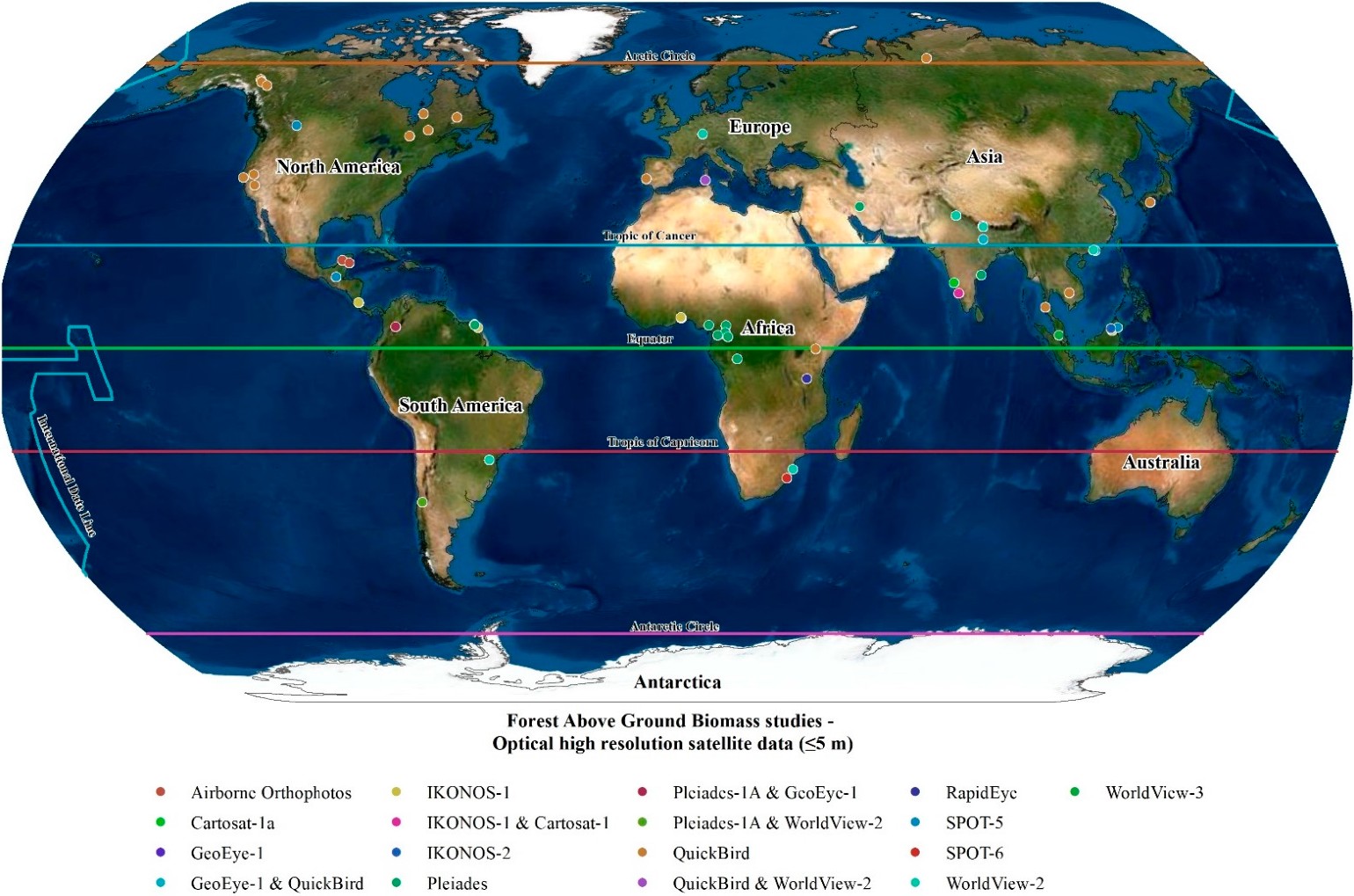
We reviewed 44 global studies (2004–2019) on forest aboveground biomass estimation using high-resolution optical imagery, highlighting common sensors, modeling approaches, strengths, and gaps, with implications for REDD⁺ monitoring and real-time biomass assessment.
Iqbal Hassan, Muhammad Asif Javed, Muhammad Asif, Muhammad Luqman, Sajid Rashid Ahmad, Adeel Ahmad, Shoaib Akhtar and Basharat Hussain
Pakistan Journal of Agricultural Sciences, 2020
We assessed agricultural land suitability in AJK, Pakistan using GIS, AHP, and eight biophysical and climatic criteria, identifying only ~13% as highly suitable and highlighting priorities for sustainable land use planning.
Si-Son Tong, Thi-Lan Pham, Quoc Long Nguyen, Thi Thu Ha Le, Le Hung Trinh, Xuan Cuong Cao, Adeel Ahmad and Thi-Huyen-Ai Tong
Geography, Environment, Sustainability, 2020
We applied Change Vector Analysis with Landsat data (2000–2017) in Duy Tien, Vietnam to capture both categorical and radiometric land cover dynamics, revealing vegetation–soil index shifts and rapid urban expansion.
Nguyen Ba Dung, Dang Tuyet Minh, Adeel Ahmad and Nguyen Quoc Long
Geography, Environment, Sustainability, 2020
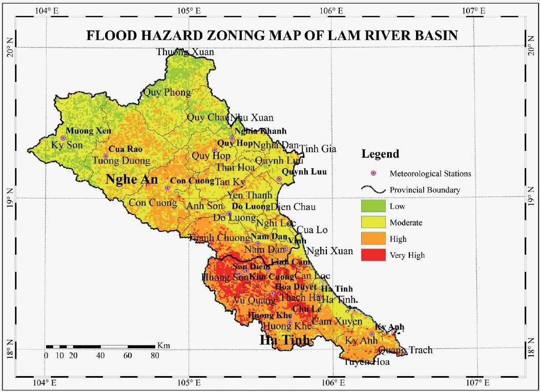
We integrated GIS and AHP to zone flood hazards in the Lam river basin, Vietnam showing that adding relative slope length as a sixth factor improved map accuracy and alignment with historic flood events.
Nasir Ashraf, Sajid Rashid Ahmad, Adeel Ahmad and Muhammad Asif Javed
Pakistan Journal of Scientific & Industrial Research Series A: Physical Sciences, 2020
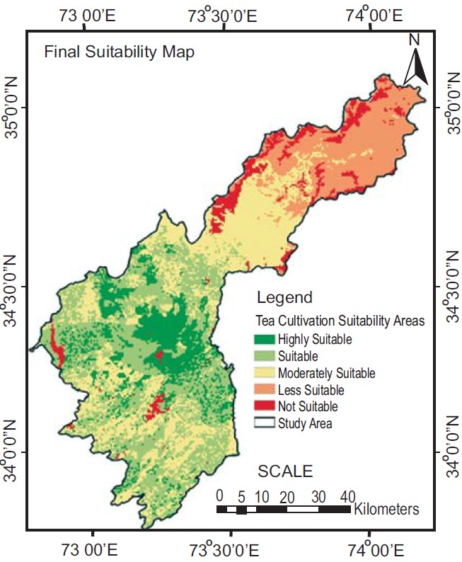
We used Landsat-8 and ASTER DEM with GIS-based modeling to identify suitable tea cultivation zones in Mansehra and Abbottabad, finding ~13% highly suitable land to reduce Pakistan’s heavy tea imports.
Safdar Ali Shirazi, Adeel Ahmad and Salman Qureshi
In Making Green Cities, 2020
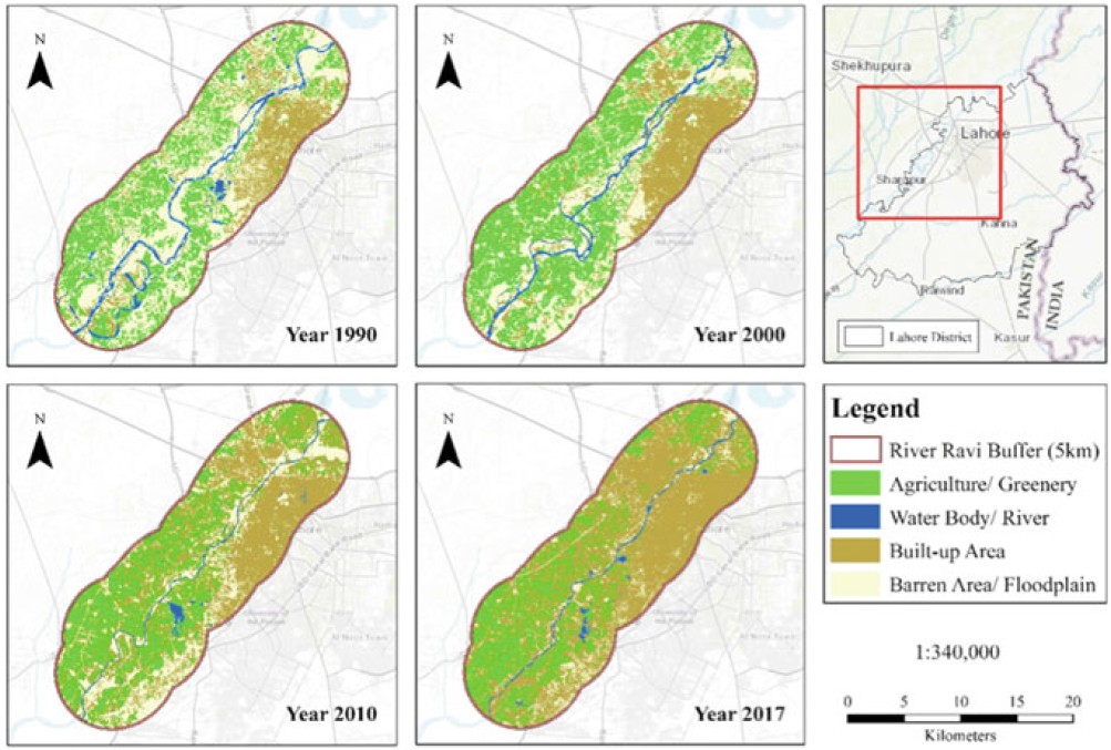
We analyzed land use and land cover change along River Ravi in Lahore (1990–2017), showing tripled urban growth, loss of water bodies and green areas, and alarming biodiversity decline linked to urbanization.
Bui Xuan Nam, Lee Changwoo, Nguyen Quoc Long, Adeel Ahmad, Cao Xuan Cuong, Nguyen Viet Nghia, Le Van Canh, Nguyen Hoang, Le Qui Thao, Duong Thuy Huong and Nguyen Van Duc
Inżynieria Mineralna – Journal of the Polish Mineral Engineering Society, 2019
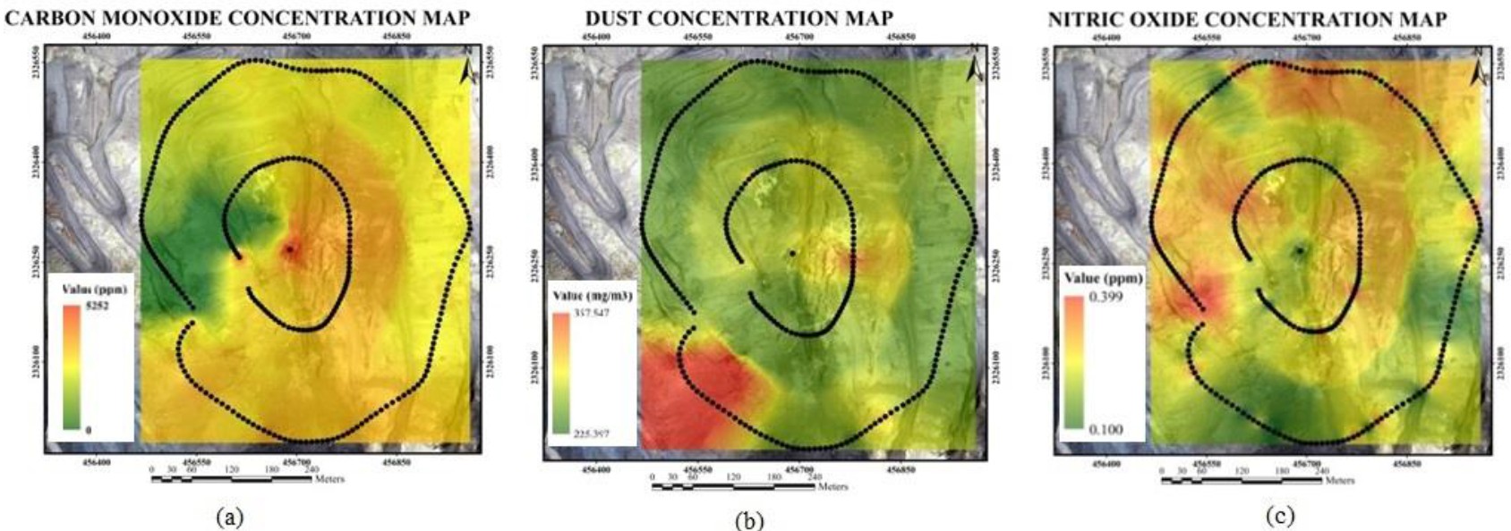
We developed and field-tested a low-cost UAV system for 3D mapping and air quality monitoring in open-pit mines, demonstrating accurate topographic modeling and pollutant detection at Vietnam’s Coc Sau coal mine.
Zartab Jahan, Faiza Sarwar, Isma Younes, Rakhshanda Sadaf and Adeel Ahmad
International Journal of Economic and Environmental Geology, 2019
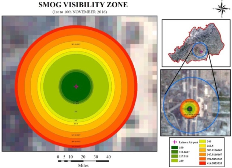
We analyzed the November 2016 smog event in Lahore using MODIS and Landsat imagery with GIS, showing dense smog cover severely reduced visibility to nearly 100 meters.
Long Quoc Nguyen, Adeel Ahmad, Cuong Xuan Cao and Canh Van Le
Journal of Mining and Earth Sciences, 2018
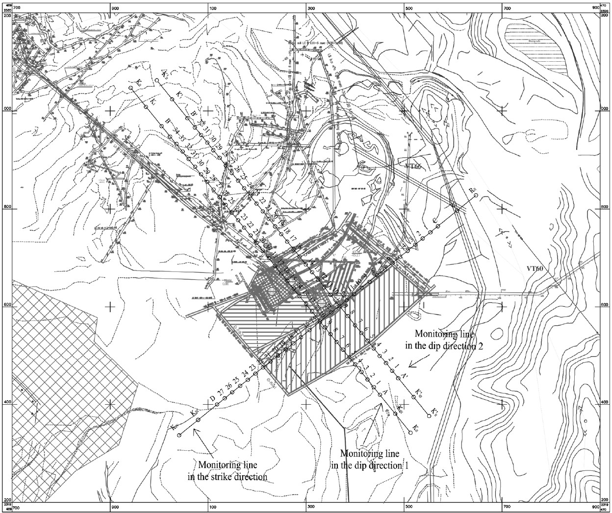
We designed three optimized observation lines for monitoring mining-induced deformation in Mong Duong colliery, proposing an improved method that adjusts the angle of draw to ensure accurate control points and compliance with Vietnam’s mine surveying standards.
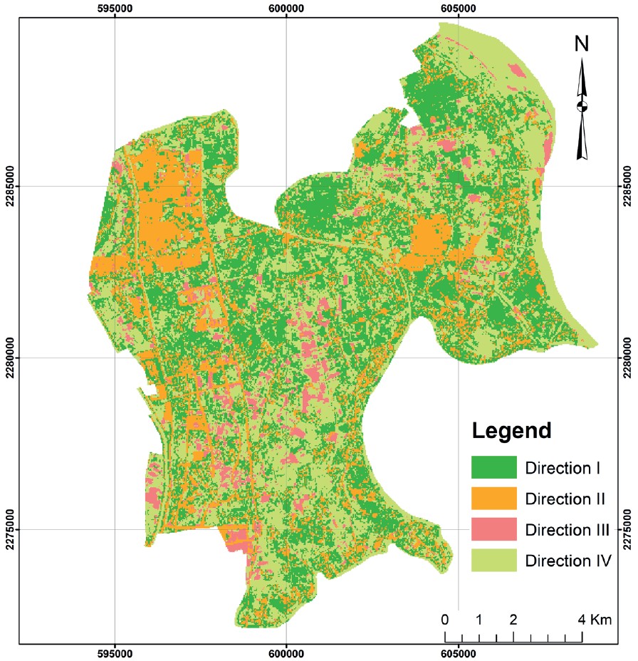
We analyzed Landsat imagery (1990–2017) to assess Lahore’s urban expansion and tree cover loss, revealing that green depletion from 2010–2017 exceeded the decline of the previous two decades.
M.Phil. thesis, published as a monograph by Noor Publishing, 2017 (ISBN 978-620-2-34061-8)
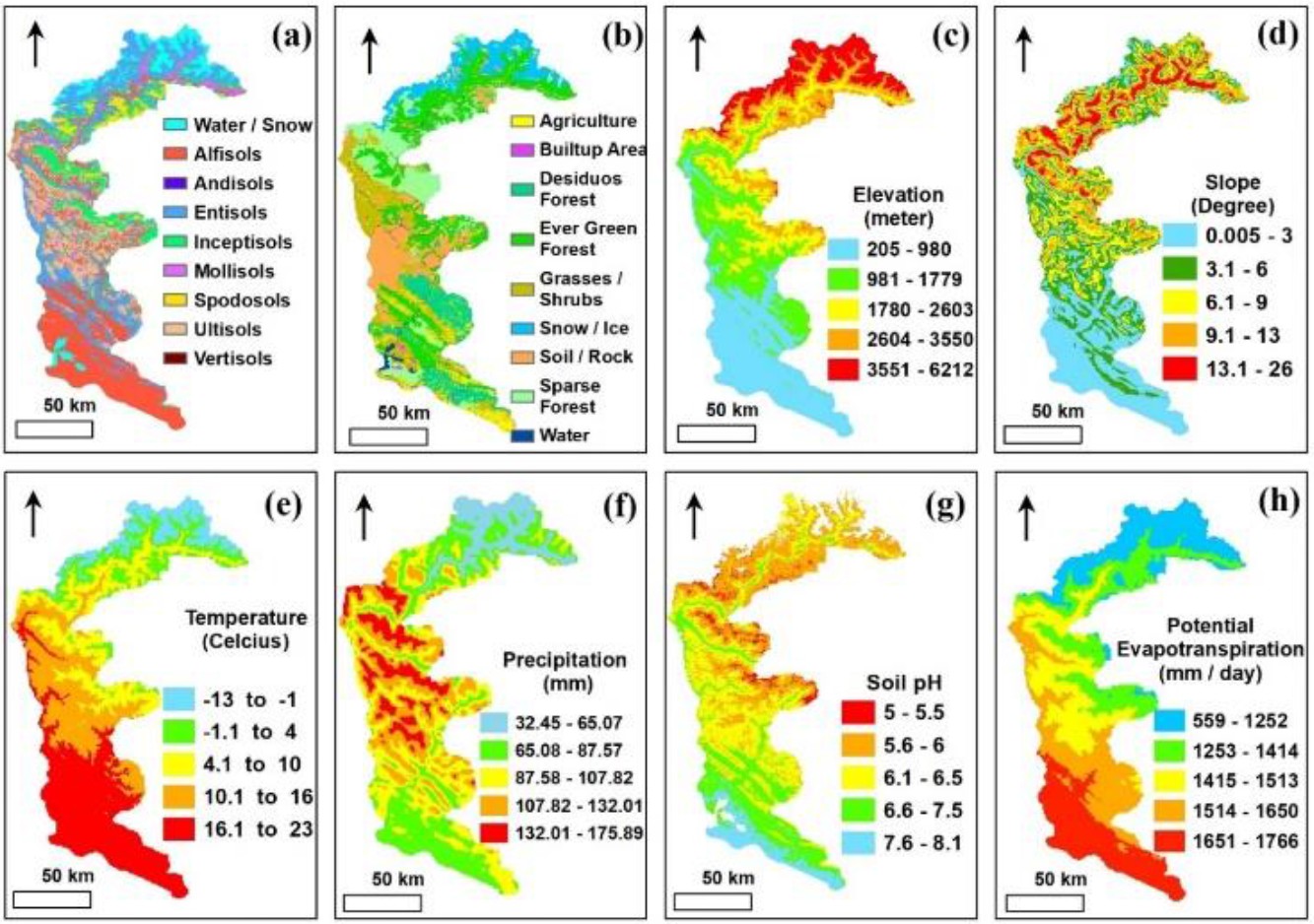
My M.Phil. research (University of the Punjab, 2011–2013), quantifying aboveground tree carbon stock in the moist temperate Himalayan forest of Pakistan by combining field inventory with satellite remote sensing and GIS.
Adeel Ahmad, Sajid Rashid Ahmad, Umar Javaid and Muhammad Asif Javed
First International Conference on Emerging Trends in Earth and Environmental Sciences (ETEES), 2017
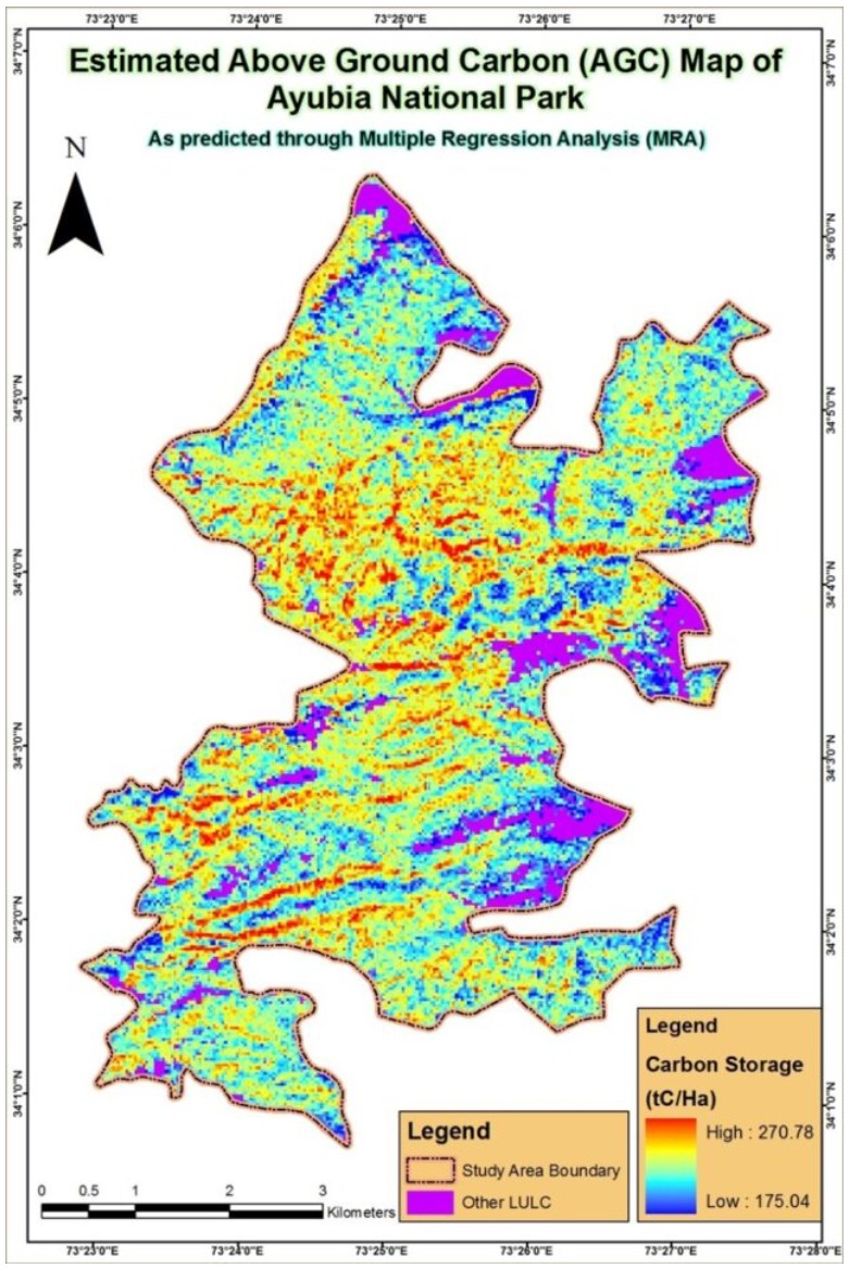
We quantified aboveground carbon storage in Ayubia National Park using field data, remote sensing, and GIS, estimating 252 tC/ha and demonstrating a scalable approach for carbon monitoring in Pakistan’s forests.
Mohsin Ali, Sajid Rashid Ahmad, Muhammad Asif Javed, Adeel Ahmad and Muhammad Waqas
First International Conference on Emerging Trends in Earth and Environmental Sciences (ETEES), 2017
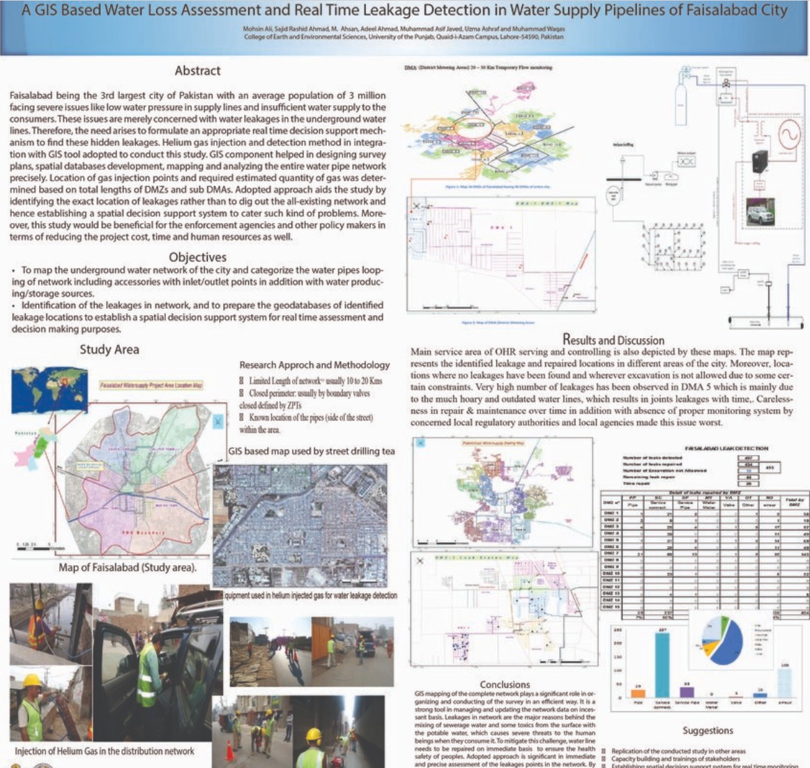
We developed a GIS-based framework for real-time water loss assessment and leakage detection in Faisalabad’s pipeline network, enabling accurate mapping of leak locations to support sustainable urban water management.
Adeel Ahmad, Umar Javaid, Muhammad Asif Javed, Sajid Rashid Ahmad, Muhammad Abbas Jaffri and Mudassar Ashfaq
Journal of Geographic Information System, 2016
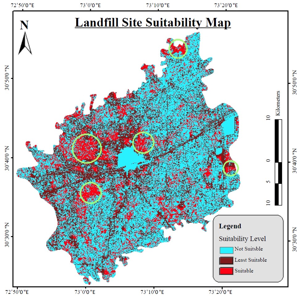
We applied GIS and AHP to identify and prioritize suitable landfill sites in Sahiwal, integrating land-use, environmental, and proximity criteria to ensure sustainable and eco-friendly solid waste management.
Umar Javaid, Sajid Rashid Ahmad, Adeel Ahmad, Muhammad Asif Javed and Azhar Ali Taj
Pakistan Journal of Science, 2015
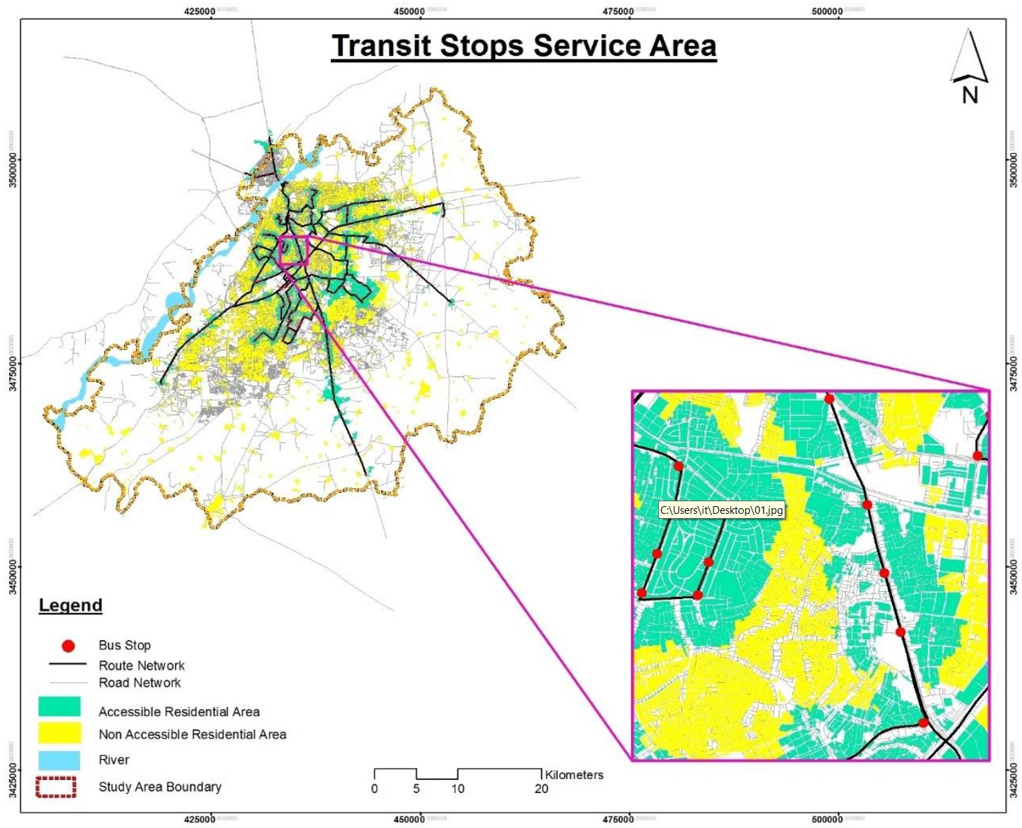
We analyzed Punjab University’s transit system using GIS-based service area modeling, revealing that only 26% of users live within an 8-minute walk to bus stops, highlighting critical gaps for future transport planning.
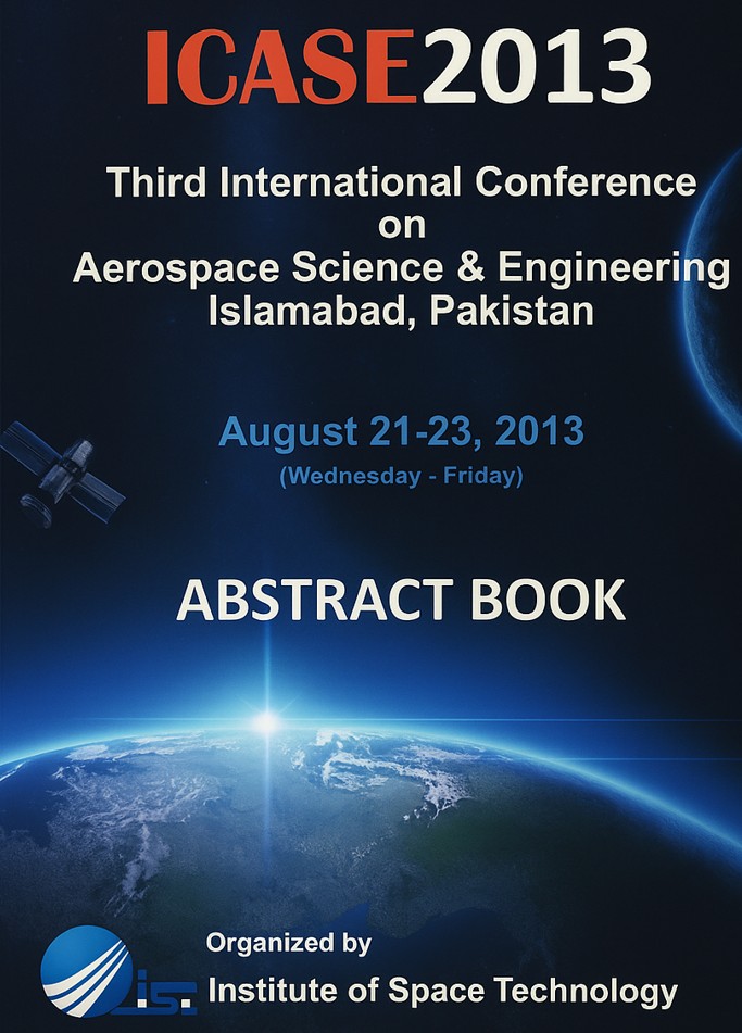
10th Meeting of the Saudi Society for Geosciences: Geosciences for Sustainable Development, 2013
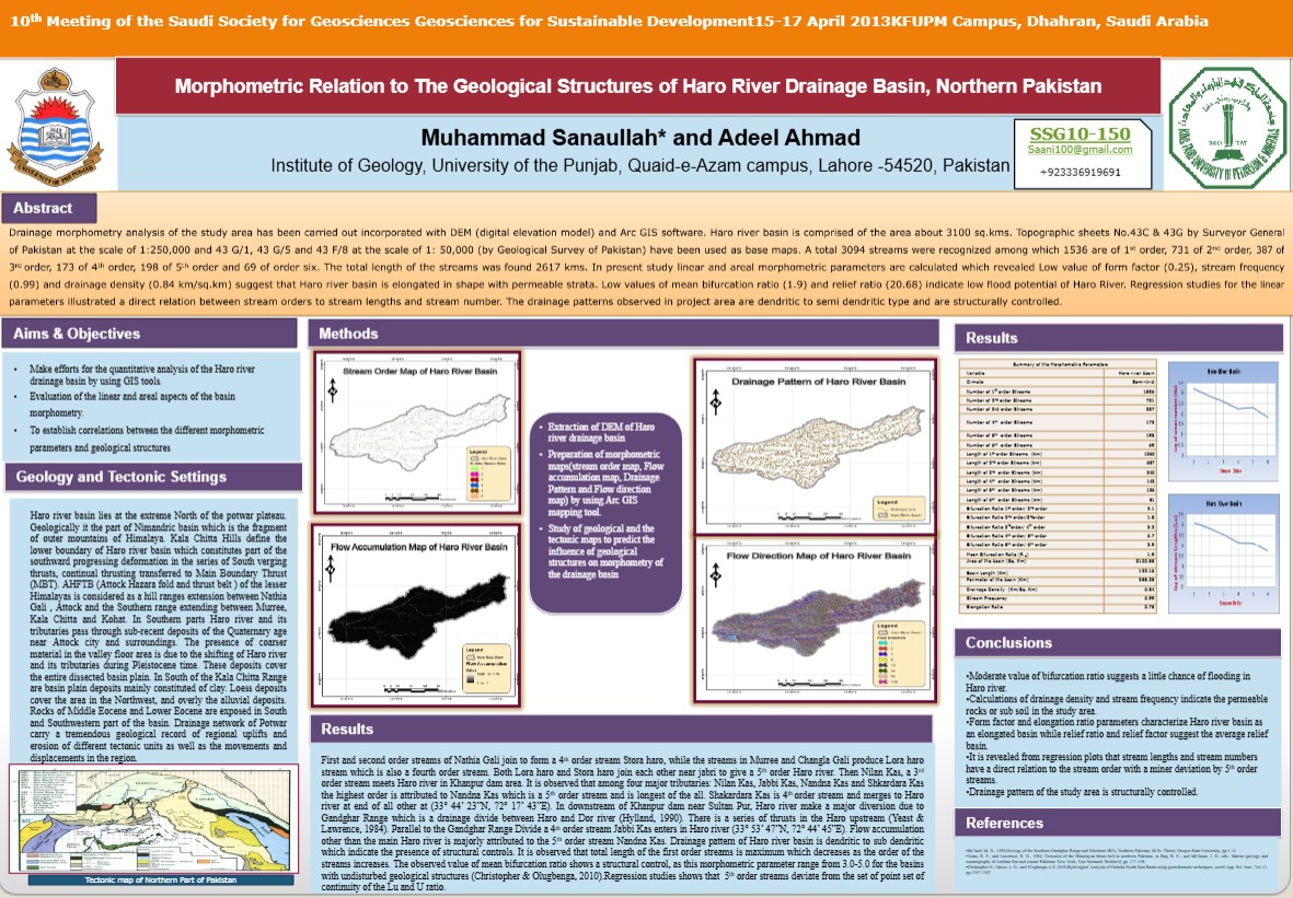
We conducted drainage morphometry analysis of the Haro River basin using DEM and ArcGIS, identifying dendritic to semi-dendritic patterns and elongated basin shape with low flood potential.
Muhammad Asif Javed, Sajid Rashid Ahmad, Adeel Ahmad, Azhar Ali Taj and A. Khan
Pakistan Journal of Science, 2013
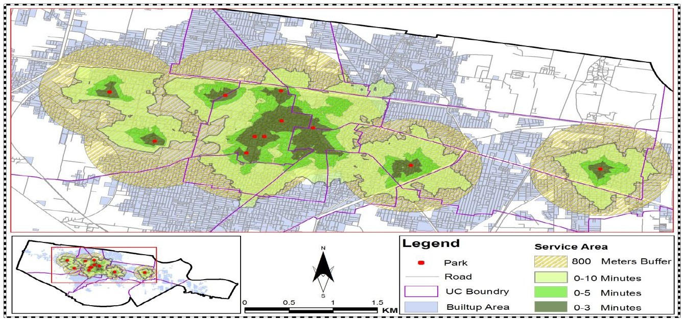
We assessed accessibility of 11 neighborhood parks in Sheikhupura using GIS network analysis, finding they serve less than 11% of the population and highlighting gaps in spatial distribution for sustainable urban planning.
5th National Undergraduate Medical Research Fair, 2012
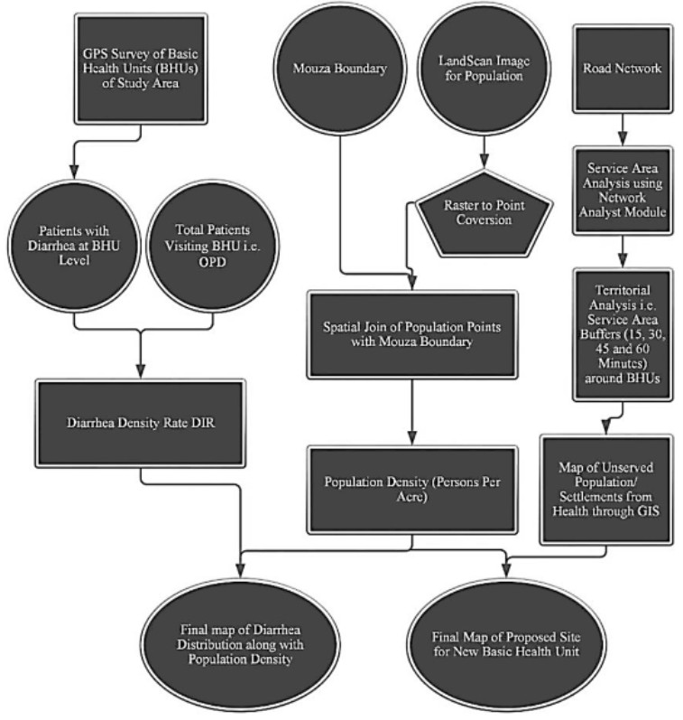
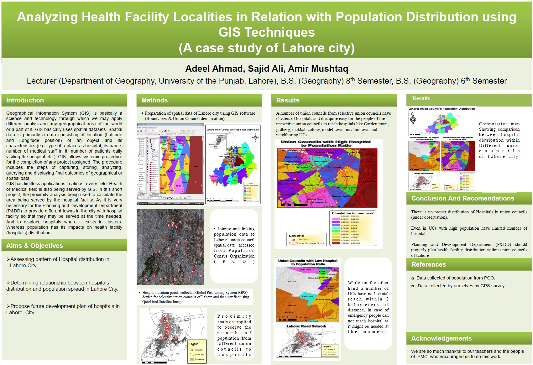
We mapped health facilities in Lahore against population distribution using GIS to assess how well the location of health services matches where people live.